Imagine Being 1st On Here With a Detector
Page 1 of 2 • 1, 2 ![]()

Imagine Being 1st On Here With a Detector
![]() by Guest Sun 29 Apr 2012, 5:18 pm
by Guest Sun 29 Apr 2012, 5:18 pm

 :.10:
:.10: 
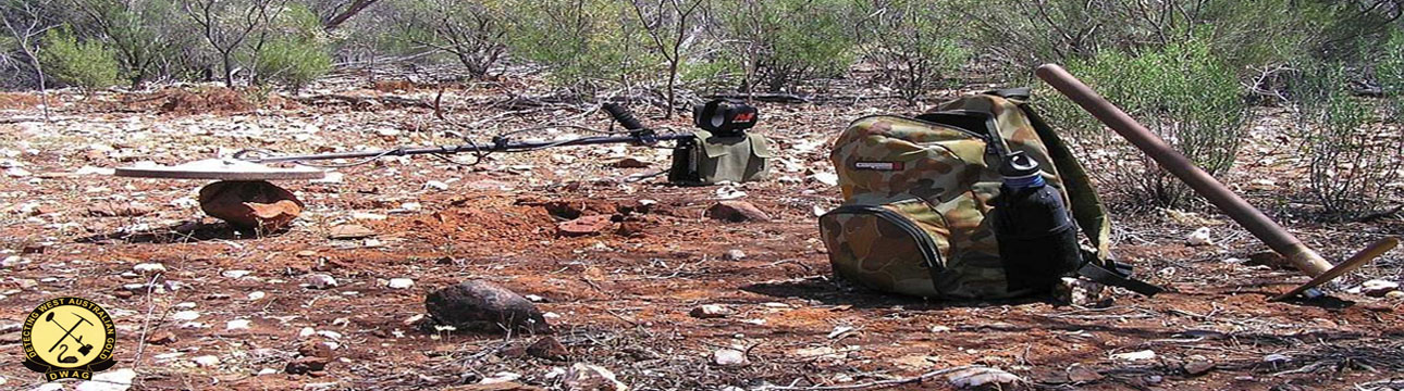
Could be Mount Charlotte in the background.

Guest- Guest
Re: Imagine Being 1st On Here With a Detector
![]() by Someday Sun 29 Apr 2012, 6:14 pm
by Someday Sun 29 Apr 2012, 6:14 pm

Someday
Re: Imagine Being 1st On Here With a Detector
![]() by Bignuggs Sun 29 Apr 2012, 8:37 pm
by Bignuggs Sun 29 Apr 2012, 8:37 pm

Bignuggs- Forum Admin
Re: Imagine Being 1st On Here With a Detector
![]() by Guest Mon 30 Apr 2012, 6:22 am
by Guest Mon 30 Apr 2012, 6:22 am
Robert
Guest- Guest
Re: Imagine Being 1st On Here With a Detector
![]() by Flying kiwi Mon 30 Apr 2012, 10:42 am
by Flying kiwi Mon 30 Apr 2012, 10:42 am

Flying kiwi
Re: Imagine Being 1st On Here With a Detector
![]() by Guest Tue 01 May 2012, 11:51 am
by Guest Tue 01 May 2012, 11:51 am
Then again,I could be wrond and the Gold may have been top to bottom in fairly deep ground.
Guest- Guest
Re: Imagine Being 1st On Here With a Detector
![]() by Guest Tue 01 May 2012, 6:02 pm
by Guest Tue 01 May 2012, 6:02 pm
Guest- Guest
Re: Imagine Being 1st On Here With a Detector
![]() by Goldbait Tue 01 May 2012, 6:10 pm
by Goldbait Tue 01 May 2012, 6:10 pm

Goldbait
Re: Imagine Being 1st On Here With a Detector
![]() by Guest Tue 01 May 2012, 6:11 pm
by Guest Tue 01 May 2012, 6:11 pm
How good would it be to hit that ground between the hill and the diggings.
Guest- Guest
Re: Imagine Being 1st On Here With a Detector
![]() by Bignuggs Tue 01 May 2012, 8:15 pm
by Bignuggs Tue 01 May 2012, 8:15 pm
http://innopac.slwa.wa.gov.au/search~S2?/tJ.+J.+Dwyer+collection+%3B+5816B%2F236/tj+j+dwyer+collection+5816b++236/-3,-1,0,B/browse
How to search a mine, with a candle

Bignuggs- Forum Admin
Re: Imagine Being 1st On Here With a Detector
![]() by Bignuggs Tue 01 May 2012, 9:00 pm
by Bignuggs Tue 01 May 2012, 9:00 pm

Last edited by Bignuggs on Tue 01 May 2012, 9:01 pm; edited 1 time in total (Reason for editing : extra word)
Bignuggs- Forum Admin
Re: Imagine Being 1st On Here With a Detector
![]() by Bignuggs Fri 04 May 2012, 3:49 pm
by Bignuggs Fri 04 May 2012, 3:49 pm

Bignuggs- Forum Admin
Cheers
![]() by MorryLorry Tue 08 May 2012, 8:24 pm
by MorryLorry Tue 08 May 2012, 8:24 pm
Thanks heaps for posting the link. Love the quality of the mining back then.
Always amazed by the underlays, and wooden backfill brattices.
OHS back then...? Huh?
MorryLorry
Re: Imagine Being 1st On Here With a Detector
![]() by Guest Tue 08 May 2012, 9:35 pm
by Guest Tue 08 May 2012, 9:35 pm

Guest- Guest
Re: Imagine Being 1st On Here With a Detector
![]() by Bignuggs Thu 10 May 2012, 9:30 pm
by Bignuggs Thu 10 May 2012, 9:30 pm
I'll even keep to the 10 foot rule if he tells me where it is
Bignuggs- Forum Admin
Mystery Alluvial Patch May Be Solved
![]() by Guest Sat 12 May 2012, 1:13 pm
by Guest Sat 12 May 2012, 1:13 pm
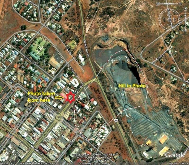
As i first thought when i posted the photo, the abandoned alluvial patch is at Kalgoorlie, its the original
run found by Paddy Hannan on 17th June 1893 below Mt Charlotte that started the gold rush to Kal.
The hill was taken up as part of the original "Mt Charlotte 211E & Hannan's Hill 97E Leases" and the spot where
Paddy Hannan's Tree now stands is within the run, the Alluvial run was magnificently rich with gold and the average depth to the wash was 14 feet.......
There is one very strange tale of a digger digging up some old Dutch artifacts dated back to the 1600's
on his alluvial claim at 2 foot deep
search for gold than thought, they may have found the spot but perished trying to get back to the coast
or been speared by the local tribesmen.


More Info To Come
Pete
Guest- Guest
Re: Imagine Being 1st On Here With a Detector
![]() by Bignuggs Sat 12 May 2012, 4:34 pm
by Bignuggs Sat 12 May 2012, 4:34 pm


Bignuggs- Forum Admin
Re: Imagine Being 1st On Here With a Detector
![]() by Guest Sun 13 May 2012, 5:58 am
by Guest Sun 13 May 2012, 5:58 am


Robert
Guest- Guest
Re: Imagine Being 1st On Here With a Detector
![]() by Bignuggs Sun 13 May 2012, 8:40 pm
by Bignuggs Sun 13 May 2012, 8:40 pm

Bignuggs- Forum Admin
Re: Imagine Being 1st On Here With a Detector
![]() by Guest Mon 14 May 2012, 12:26 pm
by Guest Mon 14 May 2012, 12:26 pm
This photo has been driving Cliff and myself nuts, dont ask why but it has, i guess
its the nature of a gold prospector to need to know.
We have had some great help from the Eastern Goldfields Historical Society in Kalgoorlie,
and the photo has been scrutinized immensely by the kind volunteers at their HQ.
We can not speak highly enough for this group of dedicated volunteers who promote and
research the history of the Eastern goldfields for future generations of Australians.
http://www.kalgoorliehistory.org.au/Home.php
Ok, this video is the end result of all the research done by Cliff,myself & the EGHS in Kal,
It will blow your mind, basically the guys took all the info and one of the volunteers actually
went to the exact spot the old original photo was taken and took a new photo...
Its a trip back in time, and YES i still wanna detect it but KCGM say No way
Pete
Guest- Guest
Re: Imagine Being 1st On Here With a Detector
![]() by Bignuggs Mon 14 May 2012, 3:12 pm
by Bignuggs Mon 14 May 2012, 3:12 pm
All I can claim is an obsession with a bloody hill :rolf:
Bignuggs- Forum Admin
Re: Imagine Being 1st On Here With a Detector
![]() by Someday Mon 14 May 2012, 5:12 pm
by Someday Mon 14 May 2012, 5:12 pm
Any culvert's along the road :bounce:
Someday
Re: Imagine Being 1st On Here With a Detector
![]() by Bignuggs Mon 14 May 2012, 5:28 pm
by Bignuggs Mon 14 May 2012, 5:28 pm
"For the past three weeks there has been a program of works widening the road at Williamston Rd Tee Junction with the Bypass road. This is about 40 metres south of Paddy`s Reward Claim.
On Friday morning they had a small backhoe digging trenches along the side of the Bypass Road opposite the Robert Street Tee junction. The first 20 meters was obviously fill for the road but then they got into about 30 metres of fresh alluvial dirt. If ?????'s call is correct , then they would have been trenching through the alluvial in the original photo in question. I will wager I wasn`t the only one drooling over it and wishing I could put it through a dryblower."
Bignuggs- Forum Admin
Re: Imagine Being 1st On Here With a Detector
![]() by Guest Mon 14 May 2012, 5:49 pm
by Guest Mon 14 May 2012, 5:49 pm
stumbling onto a single old photo.
Firstly the photo was found in WA archives
so that gave us the state it was in, next the year was on the webpage it was displayed on
so that gave us a time frame of the rush, minus say 1 year for the rush to happen and be
abandoned, next you investigate all the alluvial rushes that happened within that time frame
and that again narrows the search down heaps.
The size of the alluvial patch told me it had to be a major rush for that year which narrowed it
even more, next thing was to download the warden of the mines Mines report for that year
and that singled out only two major rushes fitting the size scale.
That report also had the mines of the district and photo's of each mine back in the days
just after the alluvial rush, those photo's showed hills very similar and in fact the same to
the original old photo - Boom Baby
Within that Mines report was also the old leases map and it all falls into place.
it was then a case of which lease had a massive alluvial rush/patch and job done.
Good luck to anyone else who may be trying to trace an old forgoten patch.
Pete
PS: and Cliff was a major player in this story i kid you not

Guest- Guest
Re: Imagine Being 1st On Here With a Detector
![]() by scratchin Wed 25 Jul 2012, 4:09 pm
by scratchin Wed 25 Jul 2012, 4:09 pm

scratchin
Page 1 of 2 • 1, 2 ![]()