Geo Maps
+3
albo
Shivan
madmax800
7 posters
Page 1 of 1

Geo Maps
![]() by madmax800 Sat 16 Feb 2013, 6:20 pm
by madmax800 Sat 16 Feb 2013, 6:20 pm
Hi All,
I am wondering if you can help me with learning to read these Geo Maps.
What do all the colours mean, what should I be looking for, what areas say on the Laverton map should I choose just from the map and why.
Do not want any gold locations(unless they have heaps of gold for me to get) but an understanding.
Thanks
madmax800

madmax800
Re: Geo Maps
![]() by Shivan Sat 16 Feb 2013, 7:41 pm
by Shivan Sat 16 Feb 2013, 7:41 pm
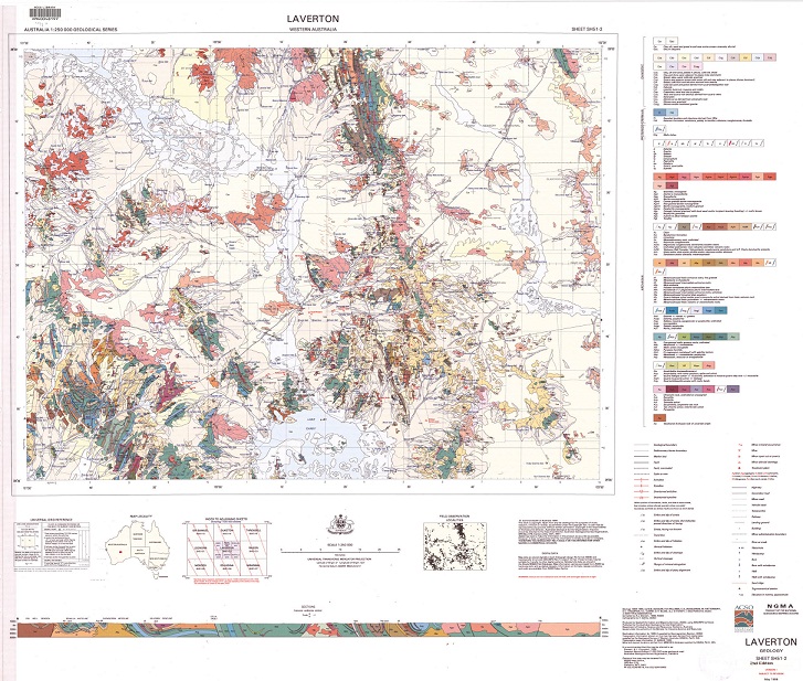
The colours realte to the different age of the rock types there should be a key on the side of the map that tells you which colours are for which age.What do all the colours mean
As for what to look for... Try and see where old mines were look at the rock type/age around the area and any other trends like faults, inclines, etc then look for similar trends in similar rock types/age.

Shivan
Geo Maps
![]() by albo Sat 16 Feb 2013, 8:29 pm
by albo Sat 16 Feb 2013, 8:29 pm
Hi Chivan , Mate i love em , all you do first stop is look at the pink colours , granite , a lot on that map , secondly look closer at 1 of those granite colours & zoom in on the perimeter of it & look for - czl on the edges of the contact of this granite, pisilitic iron stone rocks when you get there , they look like ricebubbles but black in a rock formation . also on the maps look for dolerite dykes , sometimes like at nullagine east , the dolerite dykes run N/S & the hill ranges run east / west & that was productive . ......So start with the granite & boundry ride the edges , all gold fields i know have this ..... the starting point is the begining mate & good huntin .albo.

albo
Re: Geo Maps
![]() by K town swinger Sun 17 Feb 2013, 6:22 am
by K town swinger Sun 17 Feb 2013, 6:22 am
albo wrote:Hi Chivan , Mate i love em , all you do first stop is look at the pink colours , granite , a lot on that map , secondly look closer at 1 of those granite colours & zoom in on the perimeter of it & look for - czl on the edges of the contact of this granite, pisilitic iron stone rocks when you get there , they look like ricebubbles but black in a rock formation . also on the maps look for dolerite dykes , sometimes like at nullagine east , the dolerite dykes run N/S & the hill ranges run east / west & that was productive . ......So start with the granite & boundry ride the edges , all gold fields i know have this ..... the starting point is the begining mate & good huntin .albo.

Hi Madmax,Albo has given a great explanation there and those pisolite ores on the fringes of faults and granite outcrops are a prospectors best friend.The czl areas are always worth a go even if no known gold has been found near by.
K town
K town swinger
Re: Geo Maps
![]() by madmax800 Sun 17 Feb 2013, 3:30 pm
by madmax800 Sun 17 Feb 2013, 3:30 pm
Thanks Guys,
Now I need to pull out the bigest paper copy I have and see what the heck are czl areas and pisolite ores are that you bare talking about.
One day it might sink in
Cheers
madmax800
Now I need to pull out the bigest paper copy I have and see what the heck are czl areas and pisolite ores are that you bare talking about.
One day it might sink in
Cheers
madmax800
madmax800
Re: Geo Maps
![]() by K town swinger Sun 17 Feb 2013, 5:24 pm
by K town swinger Sun 17 Feb 2013, 5:24 pm
madmax800 wrote:Thanks Guys,
Now I need to pull out the bigest paper copy I have and see what the heck are czl areas and pisolite ores are that you bare talking about.
One day it might sink in
Cheers
madmax800
Pisolite areas are over most of WA mate,the ones you need to look out for are the nice black round ones that are strewn over the ground mixed with quartz.Most of the large iron ore mining companies actually mine the underground Pisolite deposits due to the high iron content.
K town.
K town swinger
Re: Geo Maps
![]() by pilbarachad Sun 17 Feb 2013, 7:02 pm
by pilbarachad Sun 17 Feb 2013, 7:02 pm
Good info. Ive got a few geo maps that untill now ment almost nothing to me, guess ill have to go have another look at them.
pilbarachad
Geo Maps
![]() by albo Sun 17 Feb 2013, 8:20 pm
by albo Sun 17 Feb 2013, 8:20 pm
Hi again Madmax if you look to the right of the map you will see the different coloured boxes & the mineral description beside it ,czl is the light brown , ultra mafic is purple etc cheers albo.
albo
Re: Geo Maps
![]() by madmax800 Mon 18 Feb 2013, 6:54 am
by madmax800 Mon 18 Feb 2013, 6:54 am
Hi, So looking at CZL area are a good inducator, is that what you are saying . Or is it a starting place
madmax800
madmax800
madmax800
Re: Geo Maps
![]() by Bignuggs Mon 18 Feb 2013, 7:09 pm
by Bignuggs Mon 18 Feb 2013, 7:09 pm
I'm sure ya all got the knack of doing this, but if you open the link "download free geo maps" on the menu bar, then select a map sheet and then 125 view you can click on it and it expands to full view.
You would need a damn good printer to get the full exploded sheet view but at least you can get a good squiz at them.
cheers
Cliff
You would need a damn good printer to get the full exploded sheet view but at least you can get a good squiz at them.
cheers
Cliff

Bignuggs- Forum Admin
Re: Geo Maps
![]() by Guest Wed 20 Feb 2013, 8:40 pm
by Guest Wed 20 Feb 2013, 8:40 pm
Max, if you look at the top of the "rock chart" on the right hand side you'll see CZL. If you look at the bottom of the "rock chart" you'll see a lot of "green rocks" or Archaen rocks. Those Archaen rocks are formerly volcanic and are the oldest rocks in the earth's crust. Basically that "rock chart" tells you the oldest rocks formed in the earth's crust at the bottom and the most recent at the top. So CZL and the others near the top represent all the eroded, gravelly "stones" that have been moved (by many different mechanisms) from the old rocks at the bottom of the rock chart. So it is, in effect, a time chart of what rock formed and when - in millions of years. Gold can be found in almost any area where one old rock band touches another. Say granite and greenstone or basalt and ironstone, quartz and ironstone is common. The massive gold and copper orebodies are found in those huge areas but what you're looking for can be found in the "gravel" that fell of the sides of those areas millions of years ago. Some are metres deep in old flow channels. That's why I use a big yellow detector as well as those little electric ones 
Guest- Guest
Re: Geo Maps
![]() by Sporaticus Wed 20 Feb 2013, 9:03 pm
by Sporaticus Wed 20 Feb 2013, 9:03 pm
MMMMMM, love a big yellow detector, one with my name on it will do........a D10N, haha
G'day Cat, welcome to the forum, looks like you have some great input,
G'day Cat, welcome to the forum, looks like you have some great input,

Sporaticus
Re: Geo Maps
![]() by Guest Thu 21 Feb 2013, 1:14 pm
by Guest Thu 21 Feb 2013, 1:14 pm
Sporaticus wrote:MMMMMM, love a big yellow detector, one with my name on it will do........a D10N, haha
G'day Cat, welcome to the forum, looks like you have some great input,
I was a member for a few weeks last year but,,,,,,,,,,well,,,,,,,well,,,,,,,,,let's just say it was a case of "immovable object meets irresistable force" that wasn't worth the emotional capital that would be wasted in trying to rectify it. I spend 6 to 7 months a year out in the WA Goldfeilds, mostly with limited internet access, so that doesn't leave much time for anything but serious pushing and prospecting. You won't hear much from me after the April this year.
Guest- Guest
Re: Geo Maps
![]() by Guest Thu 21 Feb 2013, 1:42 pm
by Guest Thu 21 Feb 2013, 1:42 pm
aahh bet we will coz i.ll ring u to make sure u r still kickin and get an update..
regards
oneday
regards
oneday
Guest- Guest
Re: Geo Maps
![]() by Guest Thu 21 Feb 2013, 3:29 pm
by Guest Thu 21 Feb 2013, 3:29 pm
oneday monday wrote:aahh bet we will coz i.ll ring u to make sure u r still kickin and get an update..
regards
oneday
Geez, Ray, who ya gonna call? Ghostbusters? There's no mobile service where I go! Unlike "caravan park tailgaters" I actually do get to places where one can actually get a puncture but no email. (I did 3 tyres in 45 minutes year before last - 2 of 'em were brand spanking new
 . The wife knows I swear but not like THAT!
 Cat
Guest- Guest
Re: Geo Maps
![]() by Guest Thu 21 Feb 2013, 3:35 pm
by Guest Thu 21 Feb 2013, 3:35 pm
Thats the trouble when u go by geo maps--it puts u in places that your vehicle doesnt want to go..
14 or 16 ply tyres mate on split rims otherwise u get what u get--that deflated feeling..
regards
oneday
14 or 16 ply tyres mate on split rims otherwise u get what u get--that deflated feeling..
regards
oneday
Guest- Guest
Re: Geo Maps
![]() by Guest Thu 21 Feb 2013, 4:28 pm
by Guest Thu 21 Feb 2013, 4:28 pm
oneday monday wrote:Thats the trouble when u go by geo maps--it puts u in places that your vehicle doesnt want to go..
14 or 16 ply tyres mate on split rims otherwise u get what u get--that deflated feeling..
regards
oneday
Tried that years ago - just as many punctures and rips and I have to remove the tyre 'cos ya can't plug 'em. On average I seem to do better on tubeless fatties. But I must admit we were "looking for trouble" in that spot and we got in spades.
,,,,,,,,,and don't ask me how I blow tubeless tyres back on to the rim!! It's a fly spray secret and a flamin' hoot when it goes wrong,,,,,,,,,,,,,
 ,,,,,,,,,,
  ,,,,,,,,,,literally.
Guest- Guest
» Google My maps ,updating my maps ,
» Maps. Looking for more
» geo maps
» Goldfield Maps
» Ten graph maps
» Maps. Looking for more
» geo maps
» Goldfield Maps
» Ten graph maps
Page 1 of 1
Permissions in this forum:
You cannot reply to topics in this forum|
|
|